|
Happy Saturday Morning! Early morning showers won’t dampen our plans for the Memorial Day weekend. Many thanks to all who responded to our request for help! We appreciate those who are able to help as we prepare to reopen the Museum on June 11 + 12. Today our "then and now" photo features a prominent Easton landmark, the Soldier’s Monument. Located at the intersection of Center Street and Depot Street, the area was once known as Monument Square. In 1882 the area immediately adjacent to the monument was a busy area. On the northwest corner stood the Town Hall. Across the street, near the site of the current Center School, was the Town Poor Farm, and the original Centre School, now a music and antique shop. There were two churches in the area as well as parsonages. The Town Pound, a place for stray farm animals to be left for claiming, was also here. Depot Street was an important link in colonial times as it connected two early villages, South Easton and Furnace Village, as well as intercepting Bay Road which was one of the “King’s Highways” and a stage coach route. The location of the monument is also very near the geographical center of Easton and that was important once North Easton began to quickly develop with the arrival of Oliver Ames and the shovel company. 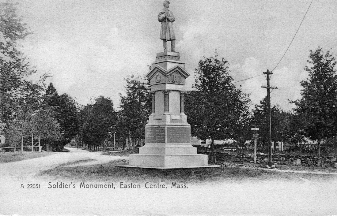 Following the Civil War, as people returned to their former way of life, the south was heavily devastated with the loss of cities, towns, plantations, railroads and shipping, and was left with a shattered economy. In the north, the physical losses were not so drastic, with a strong war economy and no loss of infrastructure. However, the effect on returning soldiers on both sides was equally devastating. Many suffered medical issues from wounds or sickness and could not perform their prior work. An untold number of soldiers suffered from depression, PTSD, or other emotional inflictions that could not be diagnosed and had no real treatment options. It took a generation to try to begin to heal the land. The assassination of President Lincoln left an open wound for many years that only added to the hurt felt by a slowly healing nation. In Easton it took almost twenty years before thought could be seriously given to erecting a suitable monument to commemorate those who gave their lives to preserve the Union. On Memorial Day 1882 the Soldier’s Monument was dedicated in memory of the forty-seven men who gave their lives in the war, and in honor of all those who made so many sacrifices and survived. The dedication book records that some two thousand people were in attendance. For years platforms were erected as a parade viewing stand for veteran’s speakers, and other dignitaries, and today (excepting the pandemic when people could not gather) appropriate ceremonies continue to be held in remembrance of our Civil War dead. In our old photo, we look at the monument and behind it Center Street running north towards North Easton. There are urban myths about Civil War memorials in the north, many of which feature a soldier. The myth is that the soldier’s look south to keep watch. A survey of Civil War monuments will show that is not entirely true. In Easton’s case, the monument is placed at the main road in the area and established a true center for government and civic activities, as well as overlooking the parade route from the G.A.R. Hall in Eastondale to the Town Hall. 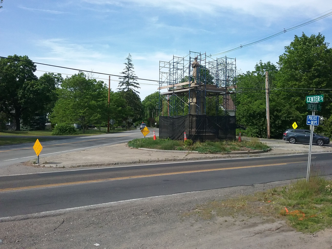
Today’s photo, taken in front of the former Read house, has raised some questions! The entire length of Depot Street has been under construction for two years now, with relocation of power poles, the widening of a heavily traveled road, additional turn lanes, and sidewalks making up the bulk of the work this year. A major component will be the redesign of the intersection of Center Street, Depot Street, Purchase Street, and Porter Street. Maybe it’s my age showing, but traveling south on Center Street to Depot, and turning west, means turning my head nearly backwards to see oncoming traffic, a very uncomfortable experience. Traveling east can mean a lengthy wait for a break in traffic. Those turning in either direction from Purchase Street run into similar issues. In order to accommodate improvements to the intersection, the Soldier’s Monument will be moved some fifteen feet to the west, allowing Center Street to be relocated to better align with other streets. Lights and turning lanes will certainly be a welcome improvement. The scaffolding around the monument is the first step in preparing it for moving. Untouched since its installation in 1882, the process of moving our memorial will be a delicate one as engineers study how it was originally assembled, how much of it should be dismantled, and of course providing a proper footing and area around the base for viewing. In a few months this familiar spot will change form, and hopefully for the better. Stay well, and enjoy Memorial Day, Frank
0 Comments
Happy Saturday morning from historic Easton! The overcast sky and early morning rain will soon burn off as Easton looks to set a record for high temperatures today and tomorrow. Time to get out the fans and air conditioners! On Sunday afternoon OAHS senior Abram Kempner will officially receive the distinguished rank of Eagle Scout. Abram’s project involved creating an online tour of historic spots one can see while walking around North Easton. He took photos, did research, and created this digital platform, which can be found on our website, and can be added to in the future. Working with Abram was a bright spot during the pandemic, and attending his Eagle Scout ceremony is something I am honored to be doing. Thank you, Abram, for a job well done and congratulations on an honor that is well-deserved! We might travel by trolley to North Easton for today's then and now photo. Our picture today was taken just about 1900. If you were to stand on the sidewalk in front of what is now 11 Center Street, and look north towards the intersection of Center, Lincoln and Main Street, you would find yourself in the same location our photographer was standing one hundred and twenty-two years ago. The subject of the photo is clearly the young lad with the horn and cap gun, wildly happy to have his photo taken with his favorite toys. Unfortunately for us, we do not know the boy’s name, nor do we know the name of the photographer. As delightful as this photo is, there is a lot to be discovered in the background. 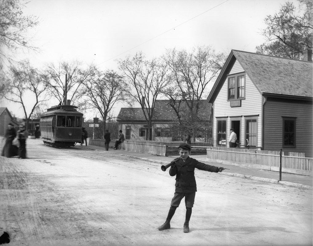 Your eyes might be immediately drawn to the trolley car. This is one of the Easton and Mansfield line trolleys, and the sign on the front indicates it is beginning its journey from North Easton center to Mansfield. You can see the track bed running along the east side of Center Street. The building on the right has a long history. First built around 1870, it was occupied for many years by Elijah Spooner, a tin ware dealer. The building was originally thought to be three stories high, though it is clearly two stories high here, and besides the tin and stove shop on the first floor, provided living space for the Spooner family until they bought a house further down Center Street a few years later. Once that happened, in 1882 the second floor became the home of the “Queset Club” of leading merchants and men in North Easton. The group met in nicely appointed rooms, complete with a pool table and newspapers, “for the benefit and amusements of the members,” of which Spooner was the first president. Various groups used the hall as well. The G.A.R. Post 52 of South Easton met there following a fire that burned their hall in the mid-1880’s. Other local clubs and organizations such as the Sons of Temperance met there too. When this photo was taken the building was occupied by Ryder’s Store, one of many small stores in the center. By 1903 George W. Swanson, a Swedish immigrant, ran a lunch room and pool parlor here, serving spirits as well, into the 1940’s. The building was occupied by the Betty Jean Shop for a number of years, and today houses a yoga studio. The top two floors were removed, possibly following a fire, and the building has been extensively remodeled several times over the past fifty years. Just to the left of that building is a wood frame house. The location of the house in the photo is misleading. At first glance, it looks like the house is on the site of the former telephone building at the corner of Center and Main Street. It is actually across the street, near the site of the current Sundell’s Citgo Station. Owned in the early 1800’s by one of the Andrew’s families in North Easton, the house was home to the Waite family when this photo was taken. A careful look to the left of the trolley will reveal the water fountain that once stood in the intersection, and cupolas on top of the Ames Shovel Factories overlook the entire scene. If that isn’t enough for your eyes to take in, look at the amount of people in the photo. The period dress is always interesting. Can you find the bicycle hiding in this photo? Today the location appears different, but still very familiar. The trolley tracks no longer run along Center Street, and the brick facade of Harry J. D. Sundell’s Gas Station reminds us of the advances in transportation that hastened the end of the trolley cars. The brick New England Telephone and Telegraph Company building, erected in 1941, now stands right at the corner of the intersection. You might remember it as being the telephone office, but most of us will remember the building as home of the North Easton (later Easton) Co-Operative Bank, which today is the Bank of Easton. The shutters on the building still retain the distinctive “Bell System” cutout, a reminder of what purpose the building was first built for. On the right is the heavily remodeled former Spooner tin shop and Betty Jean Shop, where we bought school supplies and gym uniforms – remember those? 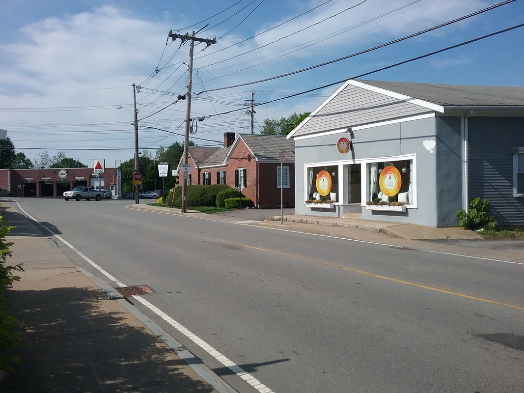 Until next week, stay well, and stay cool!
Frank Hello from sunny Easton! The sun is shining brightly this morning as children gather at Shovel Shop Pond for the annual Easton Lions Club Fishing Derby. Hopefully the fish will cooperate and provide fun and fodder for some good fishing stories and memories for these young outdoors boys and girls. 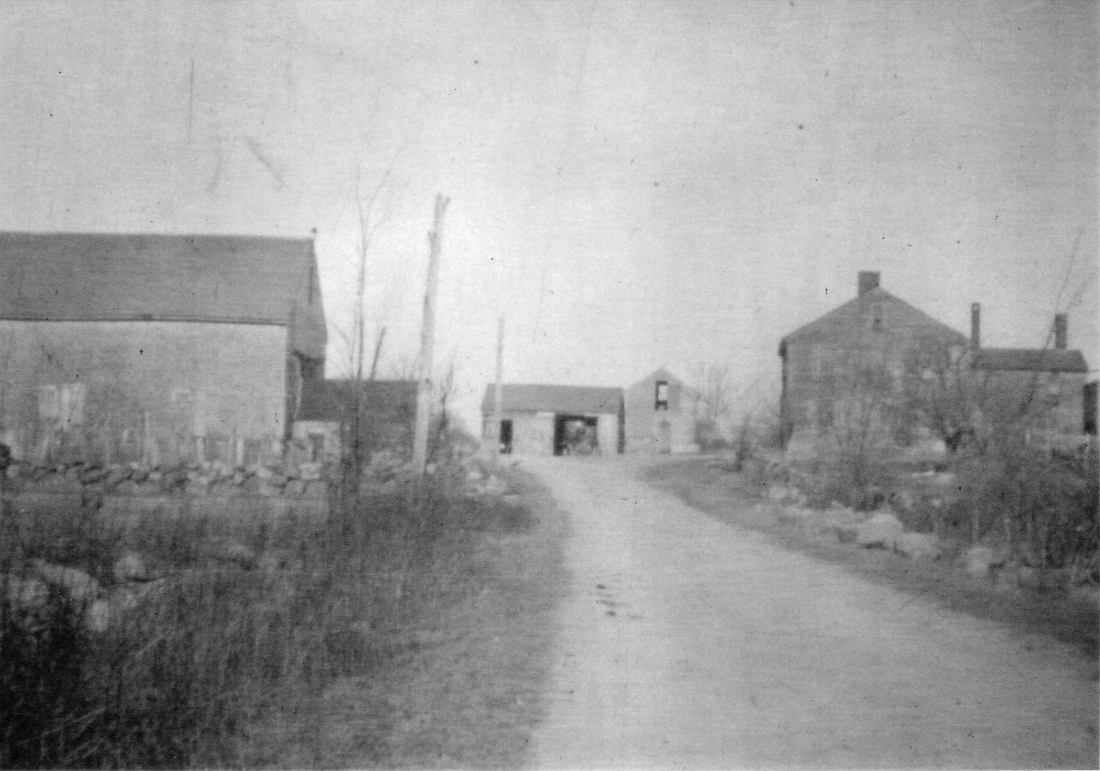 This week we venture back into the wilds of the area once known as “Poquanticut” as we take a look at Poquanticut Avenue yesterday and today. The road was accepted by the Town in 1763, and probably began life as a cart path as early as the 1750’s when there was a need to connect the early foundry industry at Furnace Village with supplies of bog iron and charcoal makers to the north and east of the village. The 1825 map of Easton clearly shows a well-developed road with a handful of houses stretched out along its path. One of these houses was built by the Harlow family before 1825. Called the Tisdale Harlow farm, the house was probably built by Reuben Harlow (1773-1823) who married Hannah Fuller before 1800. When their son Tisdale Harlow (1804-1883) was born there were two older siblings, so it is likely that the main portion of the house was built by that time. Following Reuben’s death, the house and farm were inhabited by Tisdale, then his son Tisdale Jesse Harlow (1860-1927). His son Tisdale Harlow (1904-1986) whom I knew for many years, told me that his great-grandfather Reuben built the old farm house on Poquanticut Avenue. The various maps of Easton (1825, 1855, 1871, 1886) all attach the name Harlow to the property. The 1895 map changes the name to William McLeod, who purchased the farm from the Harlow family and later sold it to the Wilbur family, who still owns and runs a farming operation there. When I was a kid in the 1960’s, the farm was called Clover Valley Farm, and was an active dairy farm for many years prior. I also remember a small meat packing plant there for a few years. Today, after a number of years boarding horses and operating a riding stable, the farm has returned to its roots with a herd of cattle populating the fields along Poquanticut Avenue and Chestnut Street. This photo, taken before 1900, looks towards Chestnut Street which lurks just behind the barn. You can see the farmhouse on the right, and the dairy barn on the left. Dead center are two small storage buildings. Although they appear to be in the middle of the road, they are not, as the road takes a hard corner directly in front of them. One gets a good feel for the rural life in Easton that once permeated much of the Town. Picture, if you will, George White and his band of thieves galloping through here on a raid, or returning to their nearby hideout with stolen goods, through an area that was sparsely populated and already had a poor reputation. Picture if you will one hundred years later when men in cars, disguised in robes, drove their cars through here and the back roads of Mansfield in the years before the Great Depression. Their “hideout” was not far away either. 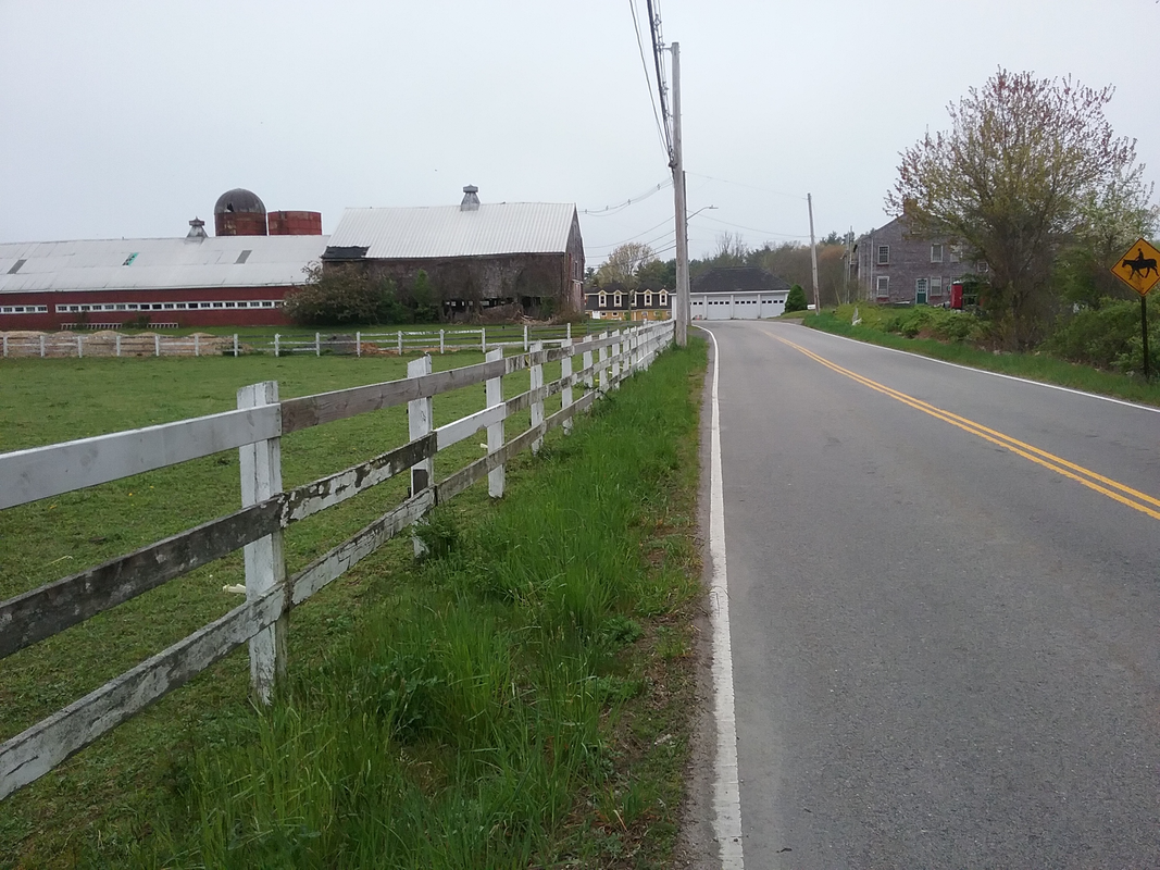 Today this area retains much of its rural beauty. The farmhouse is partially hidden on the right by growth along the road, but farmyards and fields on both sides of the road are evident that farming still proudly takes place there by hard-working people. The old dairy barn and a silo stand on the left, and you can see the later long addition to the barn as well. The two old buildings in the center were replaced by a cement block building in the 1950’s. That bend in the road caused a few headaches over the years as cars would not navigate the turn and run into the buildings. When the cement garage was built, several cars ran into the corner of the building, prompting the family to place a large boulder there. Unfortunately, at least one car hit the boulder so hard that it was pushed into the corner of the building. The farm continues nonetheless, and it is the last vestige of the many farms that once populated Easton. Hopefully that will continue for many more years to come.
Until next time, stay well, Frank Hello and a Happy Mother’s Day to all! This weekend let us take time to honor our mothers, grandmothers, aunts, teachers, mentors, and other women who were role models for all of us. Today we take a look at that neat village called Eastondale. Nestled between Washington Street and the Brockton and West Bridgewater town lines, the Eastondale neighborhood has always been a close-knit community. Many years ago, besides homes and farms, you would find within the neighborhood a store, post office, church, social clubs, trolley service, and a railroad depot and freight house among other things. Today Eastondale is gently filled with handsome homes and nicely landscaped vistas. The post office, trolley and train may be gone, but fortunately we have a terrific photo that preserves evidence of two modes of transportation that were important to the neighborhood, and Easton. The photo below, taken around 1910-20 by local photographer Webster W. Bolton, captures the moment a trolley passed below the railroad bridge in Eastondale. That’s right, there was a railroad trestle over Turnpike Street and an underpass for the trolley! A little explanation is required for this. 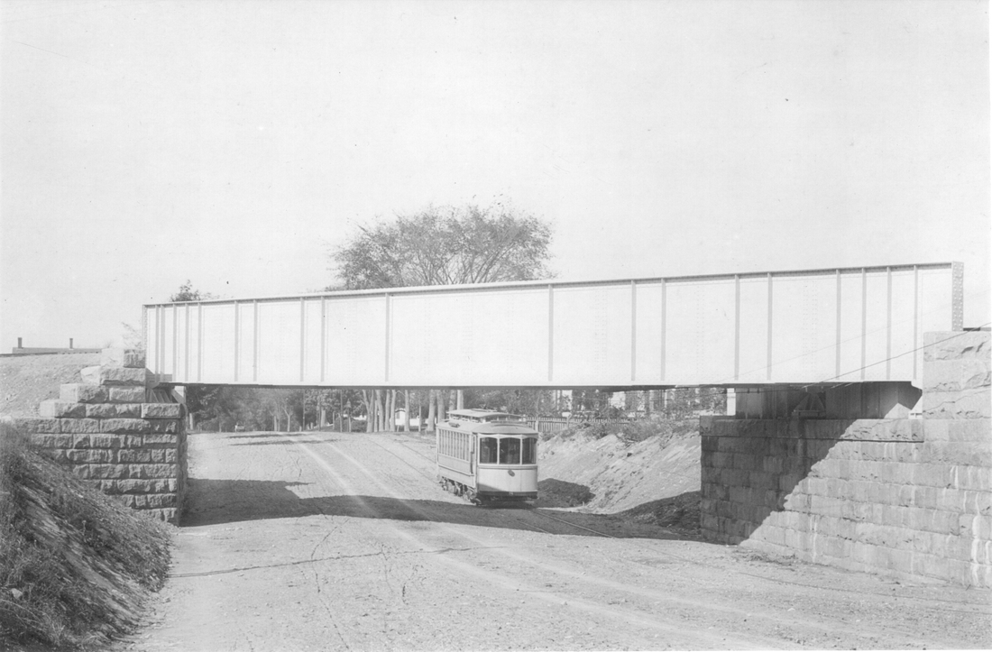 While train service had been established through Easton following the end of the Civil War, there were few connectors between main lines. As the demand for freight grew, connecting lines called “spurs” were established. One of these was a line from the main track in Easton to South Easton, through Eastondale, and into the Matfield section of West Bridgewater. Sometimes called the “Shovel Handle” route, it crossed Pine Street, High Street and Turnpike Street on its way out of town. This spur appears to have been in use in the very early 1900’s. Meanwhile, a new mode of transportation was quickly growing across America. Trolley cars began appearing in Easton in the late 1880’s, and by the turn of the 20th Century there were four trolley car companies operating lines in and around Easton. One of these, the Taunton and Brockton Street Railway Company, began a route from the trolley car barn at West and Belmont Streets in Brockton in 1897. The route ran west along Belmont Street, turned south onto Washington Street at Morse’s Corner, turned east onto Depot Street, and then turned south along Turnpike Street. The tracks ran parallel very near the edge of the road or sometimes in the roadway itself. Trolley service provided more flexibility in travel. With trolley companies merging lines and providing multiple connections, one could easily travel by trolley to practically anywhere. Soon trolleys began moving freight as well as passengers, and even provided mail service three times a day. The competition for business did not sit well with railroads. Railroads did not allow trolley tracks to cross their own tracks. This created an expensive dilemma for trolley companies, who either had to go over or under the railroad tracks. So, along quiet Turnpike Street, an underpass was dug and a bridge erected to allow both rail service and trolley service to co-exist ( the trolley. The photo here shows one of the “Ghost Line” cars (so called because the off-white color cars created a pallor) in the underpass with the railroad bridge above it. You are looking north towards Brockton, and between Hill and High Streets. The railroad spur was discontinued before 1930, and trolley service gave way to the automobile. By 1932, neither train nor trolley ran through Eastondale, and by the end of World War II all tracks and the bridge had been removed and the street leveled. Today, there is barely any reminder of either the train or trolley traffic that once served a busy neighborhood. This photo was taken near 107 Turnpike Street, looking north towards High Street which would be in the distance on the left. On the right near the center of the photo is a newer street called Marisa Drive, and it is here that the underpass and railroad bridge once inhabited the area. All that remains is a slight dip in the road, just at the intersection of Turnpike Street and Marisa Drive, to remind us of what was once a very busy and industrious neighborhood. 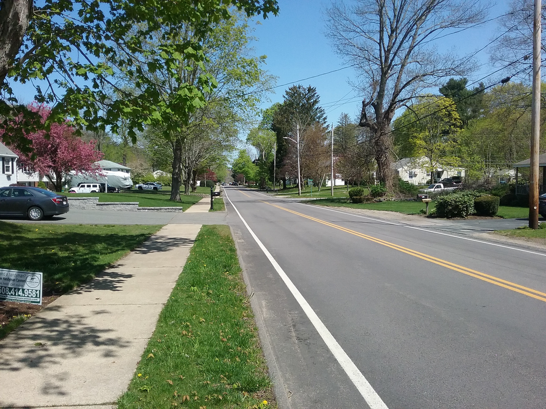 Until next week, stay well!
Frank |
Easton Historical Society and Museum
PO Box 3
80 Mechanic Street
North Easton, MA 02356
Tel: 508-238-7774
[email protected]