|
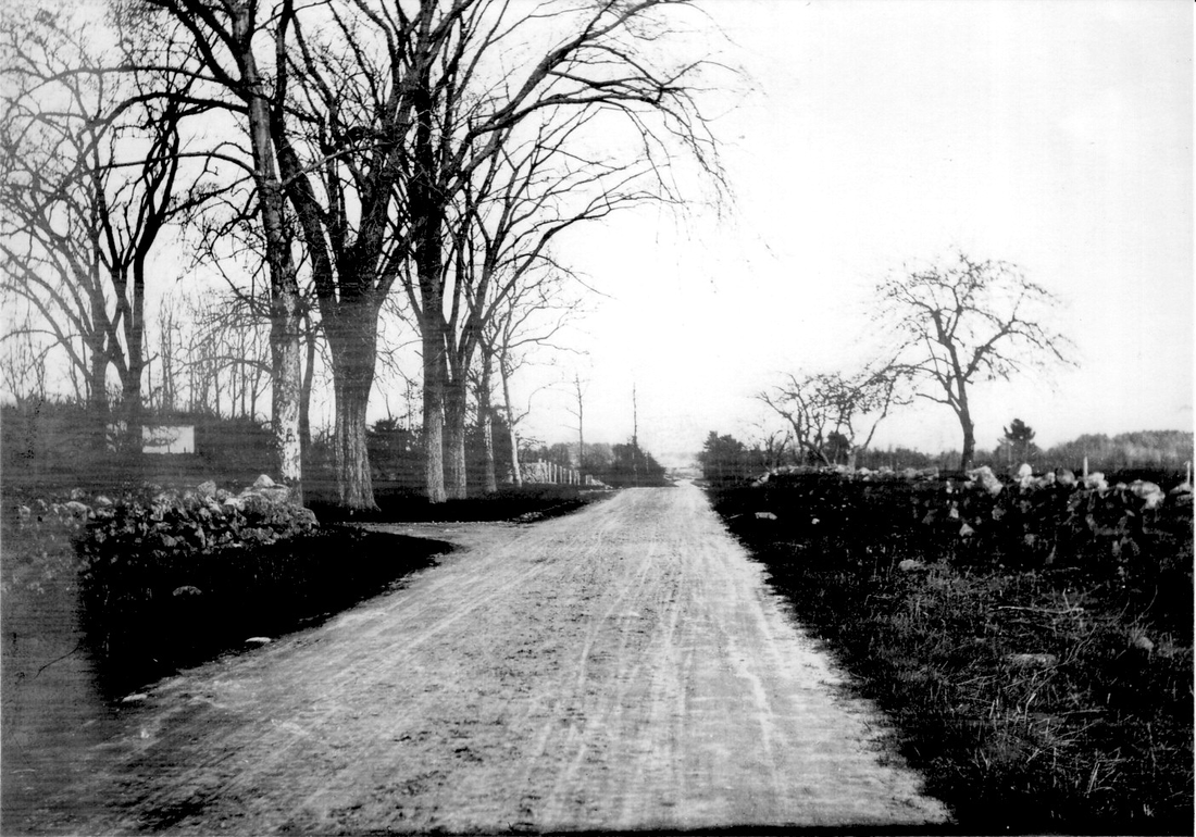
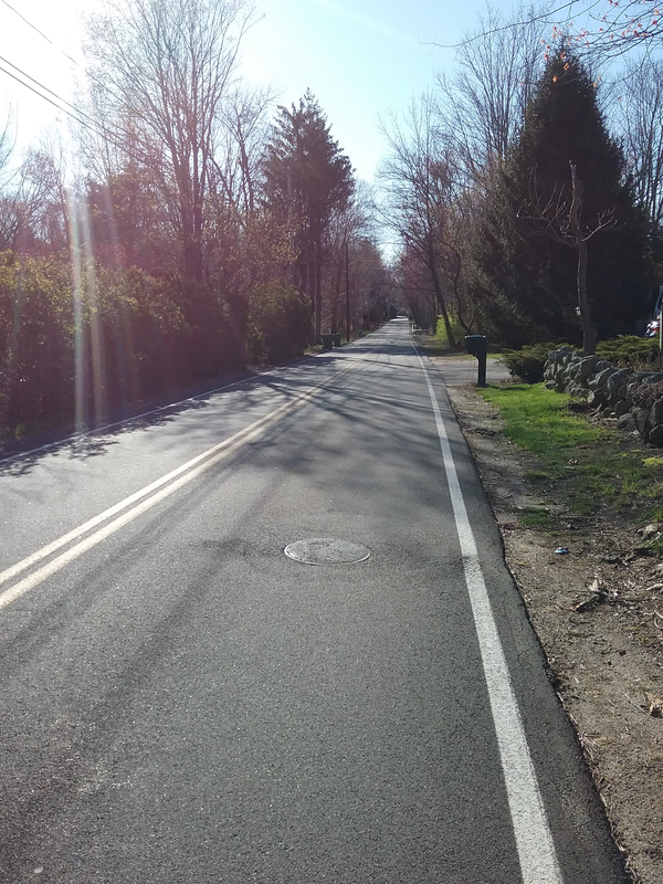
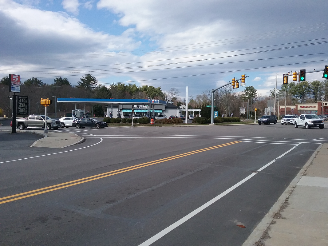
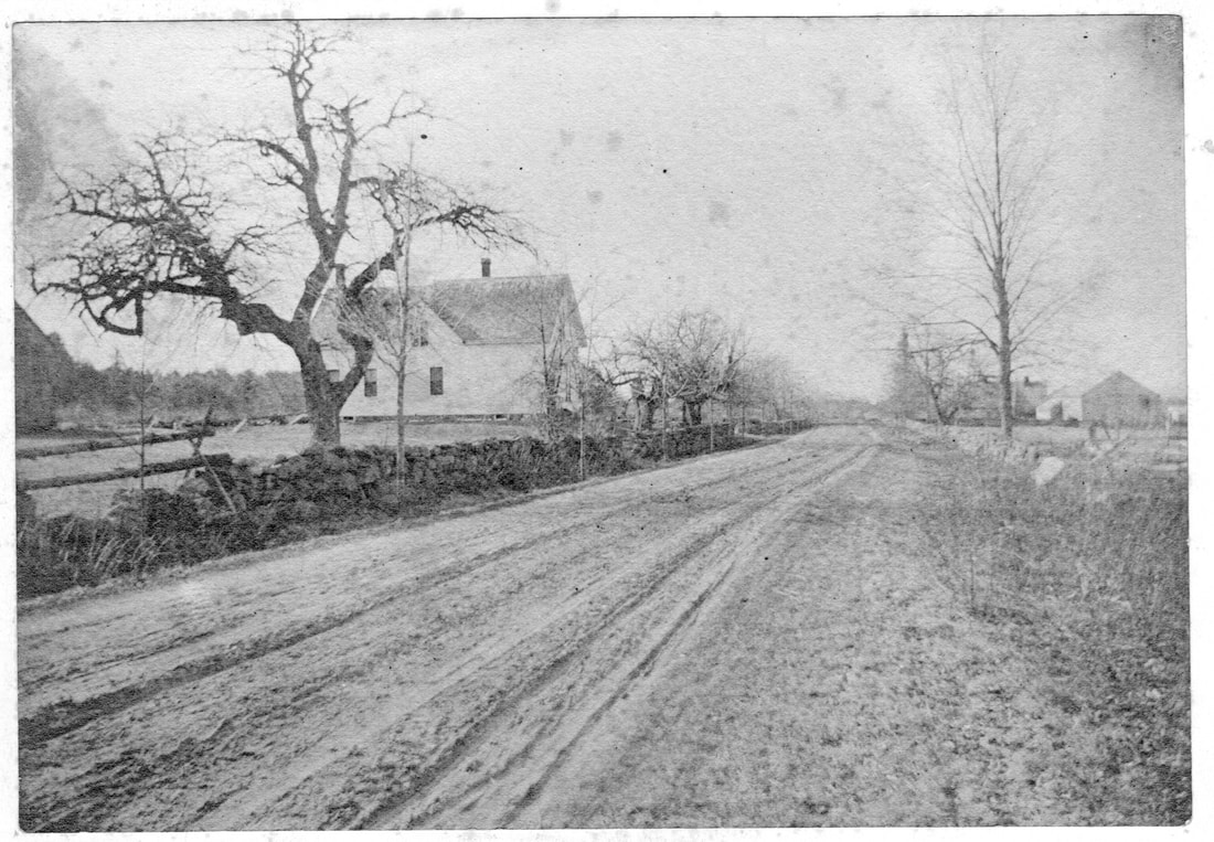
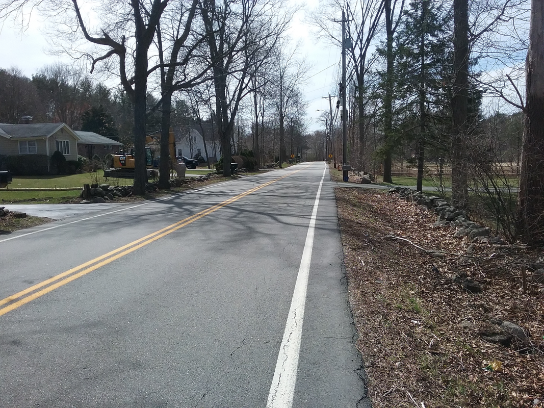
Hello from beautiful Easton! Driving to the Museum today I couldn't help but notice the natural beauty the Town has to offer. Daffodils, crocuses, and a variety of flowering trees are out in their glory, and all of the trees around town are beginning to show their spring tresses. As April comes to a close, May has its promise of bringing us all something beautiful. Today is tinged with sadness as we announce the passing of Mrs. Esther D. Ames, wife of the late Senator Oliver F. Ames. A great supporter of the Society, she graciously opened her home “Langwater” for memorable Society events over the years, including a wonderful dinner for our 65th Anniversary, and a night to celebrate the success of the Friends of the Ames Shovel Works saving those buildings from ruin. Mrs. Ames was a most gracious host, and many times she shared important advice and words of encouragement with this curator, which were appreciated beyond measure. Please join me in sending our most sincere sympathy to her children, grandchildren, and family and friends. Our original photo today looks a little forlorn, and if Currier & Ives were looking for a forgotten country lane, this one might be just the thing they would be looking for. Nothing in the photo below denotes anything of value worth photographing at all, yet someone with an artist's eye captured a timeless image of a road that was once an important part of Easton’s history. This is Massapoag Avenue, circa 1910. This photo was taken very near the Archippus Buck House at 97 Massapoag Avenue. The Buck house was built around 1825, and on an 1825 map it appears with another Buck house in a no-man’s land between what is now Chestnut Street and Rockland Street. No road through that area shows on that map, but there must have been cart paths to those houses, and one of those paths eventually became a road connecting Easton Furnace to Sharon. In colonial times, bog iron was in demand by foundry owners. A source of that material was located in a large bog in Sharon, a few miles from the Easton border. Furnaces in North Easton could access the bog by way of Lincoln Street to Bay Road to Allen Road to Rockland Street (the very upper end of Massapoag Avenue was created as a connector from Rockland Street to the Sharon town line prior to 1825.) However, the iron furnaces at Easton Furnace had no direct route to those resources. By 1825 a road had been introduced to me that need, but was not accepted by the Town until a little later, which probably explains why the entire length of Massapoag Avenue is not shown on the 1825 map. This was soon resolved, and a direct link from Easton Furnace to Sharon was in use shortly thereafter. The great bog that provided that ore was turned into Lake Massapoag which gives our road its name. The road runs through that section of Easton once known as “Poquanticut” and, along with Poquanticut Avenue, Chestnut Street, Mill Street and Rockland Street, defined a rather interesting area. As you can see from the photo above, looking east towards Poquanticut Avenue, there is very little sign of settlement. With the exception of a house very near Poquanticut Avenue, there was nothing but farm and field until you get nearer to where Mill Street crosses. The neighborhood seemed to be a great place to live if you did not want to be found or bothered by anyone. The area had a reputation that “nothing good happens there” during the 1700’s and well into the 1800s. Nearby was a hideout for a notorious gang of thieves, members of the Selee family who were feared of practicing the black arts, a mill that was supposedly run by imps, and charcoal makers (such as Quanticut Smith) who lived alone in the woods for months on end and tended to be rough characters. Even as late as 1910 one could get the impression from this photo that this was a good place to stay away from, especially after dark. Taken from approximately the same spot two days ago, the photo below shows what appears to be a relatively rural area. Many of the once cleared fields have given way to forested landscapes, though stonewalls still mark where those fields once provided feed for cattle and crops. Indeed, one gets a feel for rural living driving along Massapoag Avenue today where there are still undeveloped stretches of land mixed with handsome houses. There are not many streetlights today along the road, so there are stretches where darkness still pervades the area. The horse thieves, charcoal makers and others have long passed into history. Still, in the late hours of night, a slow ride along Massapoag Avenue might send shivers up your spine. Perhaps in the darkest of night you might want to take the more travelled road, or take the advice of our ancestors and wait for daylight before risking a visit to old “Poquanticut.” Stay well,
Frank
1 Comment
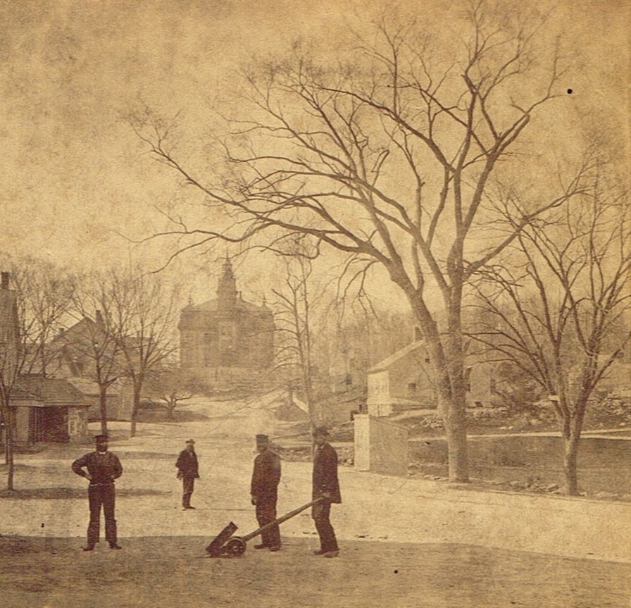
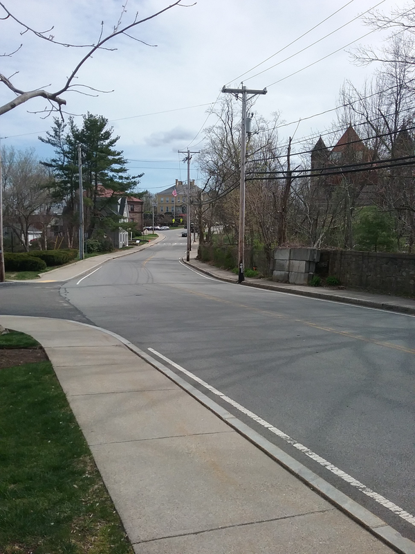
Happy Saturday Morning! A chilly start to the day reminds me that while spring arrived according to the calendar, there is still a way to go before planting gardens and other activities can fully be enjoyed. Last week we took a look at the Ames homesteads on Main Street, and the creation of a beautiful streetscape. If you stood at that same spot and looked in the opposite direction, you would see your view for today. While a glance northward gave us a look at handsome homes and a developing neighborhood, a look southerly told a different story. Taken about 1870, this photo of Main Street reminds us of what a working-class area looked like just after the Civil War. The focal point of the photo are the four nameless men captured in the forenoon of a work day. Posing for a photo had to be a big deal then and the men must have enjoyed the novelty of the whole process. You can easily see the clothing worn by the workers. I believe they all have beards too, and each sports a hat as well. The man on the right is using a “Johnson bar” or a J Bar for short. A long wood handle attached to an iron tongue and iron wheels made moving a heavy object much easier. Since that man appears to be somewhat better dressed than the others, he must have been a lead man or supervisor in the Shovel Shop. The item he is moving may be one of the dies used to form shovel blades. Of course the real story here is the changing streetscape. Main Street is a well-maintained gravel road and wide enough to handle wagons and coaches, the usual mode of ttransportation. The original Easton High School building, erected in 1869 by the Ames Shovel Company, dominates in the background. The buildings on the left are associated with the Shovel business and other neighborhood enterprises. On the extreme left is the facade of what once was the location of the Ames Company Store. In another building just behind that was the location of the North Easton Post Office. The upper floors of these buildings were used either as a boarding house or as a meeting hall, one of a number of small second floor meeting places for various social groups. Just beyond that is a glimpse of the old cape house across from the current library. Called the Sampson House for many years, it dates to the mid-1700’s and may be the oldest building still standing in North Easton. Beyond that are two buildings that housed a bakery, store, barber shop, and other businesses over the years. Upper stories contained rooms for rent. Just in front of the school building, the road appears to split, with Main Street continuing to the left, and a turn to the right connecting to Lincoln Street. A small green space appears as well, which at one time was occupied by a small church building and a small school house. The buildings on the right have an interesting history. The cape style house behind the tree is thought to be the 1795 Methodist Meeting House, and once stood on the corner of Elm Street and Washington Street (see a previous writeup on the Old Square Top Church for more information.) When the Square Top Church was built in 1830, this small building was moved to the rear of the church property, but by 1831 it had been sold to an English man named Trimble (possibly Trumble) who moved it to the spot it occupies in this photo. He and others used it as housing. Just behind this building in the photo is a faint image of a second building, once known as the “Honeymoon Cottage.” The house sat very near the road and in front of a large granite outcropping. It is here that future Governor Oliver Ames and his new wife Anna spent their honeymoon in 1860. The couple may have continued to live in the house until he finished his own home a few years later. The Ames Shovel Company owned the house at this time, and used it as a boarding house for a number of years. Both of these buildings were moved between 1877-79 to make room for the new Ames Free Library and Oakes Ames Memorial Hall. The Honeymoon Cottage was moved a short distance southwest to what is now 11 Lincoln Street, and continued to be rented out. Dr. Willis Stevenson lived there for many years in the early 1900’s. By the late 1930’s the house was sold into private ownership and was lived in by a Drake family, then for many years by the Albert Smith family. The former church meeting house was moved to what is now 85 Lincoln Street, where it was a company house for many years before being sold into private ownership. Today the view from that same location is very different. Finished concrete sidewalks and a paved road have replaced the old gravel road. The former boarding house still stands on the left, and hidden just behind that is the old Sampson house. The fork in the road now turns around the Rockery, and the original 1895 Oliver Ames High School stands on the site of the old Easton High School. Visible on the right is Oakes Ames Memorial Hall. The Ames Free Library sits back and mostly out of view in this photo. An overgrowth of trees and other bushes hides a long stone wall. A barrier of large concrete blocks marks the location of a breach in the wall created by the collapse of the Flyaway Pond Dam in 1968. Here the Queset River quietly flows under Main Street and under the Shovel Shop complex, where it once provided water power in the early years of the company. Until next week, stay well, and do great things!
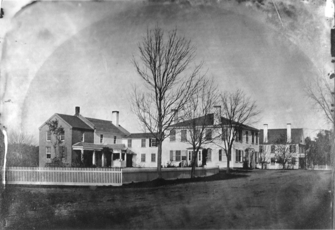
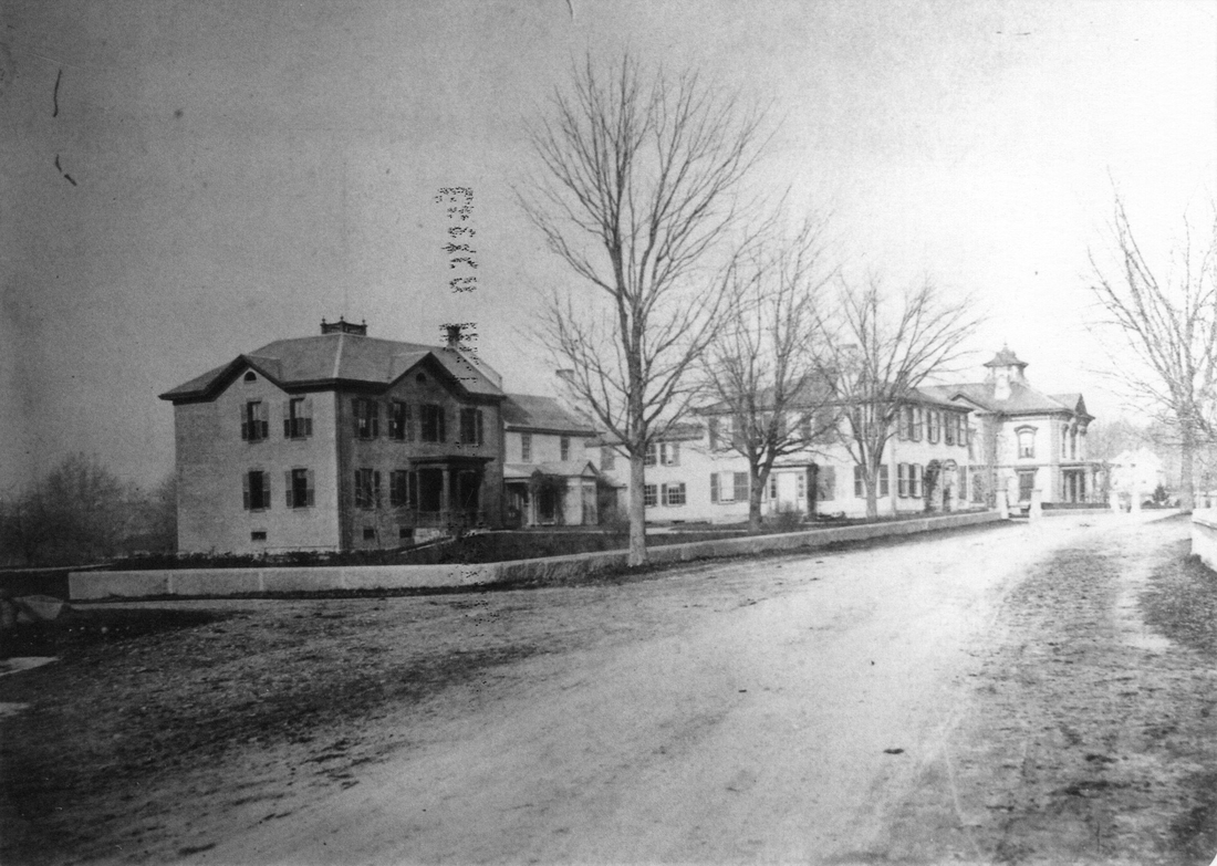
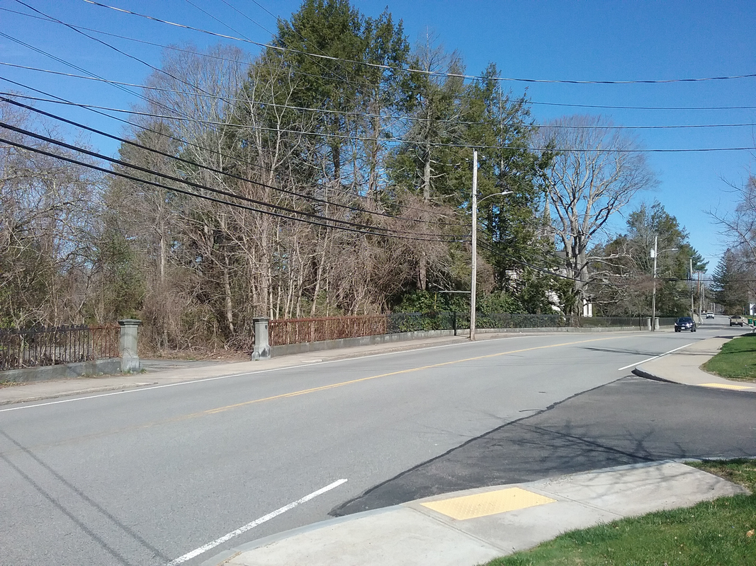
Frank Happy Easter and Passover greetings to my fellow history lovers! Today I have a triple treat for you. The three photos featured today (two period photos, one I took earlier this week) give a glimpse into one of the earliest documented landscapes being developed in Easton. Our subject today is the area of 23 -25 Main Street, looking north from one of the entrances into the Ames Shovel Shops. If one stood on Main Street at the corner of the driveway just south of the current Ames Company Stable, you would be in the right spot. The intersection of Main and Oliver Streets would be about 500 feet to the north, or at the extreme right of these pictures. In 1813 Oliver Ames, founder of the shovel business in Easton, erected a stately home on what would be 25 Main Street today. That house is featured prominently in the first of our photos, taken in 1855. The square Federal style house is the star of this image. Much larger than just about any home in Easton at that time, this handsome home must have been a welcome sight after a long day at the shops. By the time this photo was taken, Oliver had brought his sons Oakes and Oliver, Jr. into partnership with him, and was turning over the running of the business to them. The 1852 Long Shop had been built on what would become the new site of the shovel works. Oliver kept a closely held interest in the company, regularly walking through the plant to keep a close eye on things and make sure things were going to his liking. Siting his house almost directly across the street from the future factory site had to be a result of his forward thinking and vision for his business. One fact about the original house is that it was eventually divided into two separate living areas. Oliver Sr. lived in one side as he aged, and Oakes and his growing family lived in the other half of the house. Both entrances appear to be shown in this photo. Also in the photo, attached to the rear of the house, is a two-story ell that may have provided a summer kitchen on the main floor, and a few rooms for the staff that the Ames family was employing at that time. We know from the diaries of Evalina Ames (Oakes Ames’s wife) in 1851 and 1852 that she had domestic help living there, a possible gardener/handyman on site, and also boarded one of the young female teachers who taught in the schoolhouse nearby. At the left is a brick extension that was the Ames Counting House. The house to the right was built by Oliver Ames, Jr. around the 1830’s and Oliver’s idea of a family homestead lot came into being. If you look at the landscaping, you can see neat white picket fences and lawns, trellises and plantings of trees. We often think of the work done by Richardson and Olmsted in the 1870’s and 1880’s as being the beginnings of beautifying North Easton, but it appears to me that the root of this movement was planted by Oliver Ames many years prior. Our second photo shows a progression of both home and landscape. Taken about 1863, this photo bears witness to the continual development of the homestead site and the surrounding landscape. Again, Oliver Ames’s original house stands in the center of the photo (he died in 1863) but a number of changes have occurred in the eight years since the original photo was taken. On the left, the Ames Counting House has more than doubled in size, a clear indicator of the health of the company. It would also house two banks. At the right, Oliver Jr.’s original house has been replaced by a new Italianate style mansion which was built within a year prior to this photo being taken. “Unity Close” would become its given name once Unity Church was built in 1875. The grand house clearly shows the rapid development of the family’s wealth at that time, yet one gets the idea that some restraint was also shown. A disastrous fire at the original shovel shop site on Shovel Shop Pond in 1852 prompted the relocating of the new shops onto their current site. More importantly, the fire had an effect on the young generation of Ames's as every house erected by the next few generations were built of either stone or brick – except Oliver Jr.’s new house. He decided to stick with wood construction, even though his son and nephew had already built homes from stone. Just as importantly, the landscaping continues to develop and improve. The picket fences have given way to a nicely laid cut granite wall and stone columns that mark the entrance drive into the estates (an iron fence would later be installed on top of this wall, giving it the look it has today.) This may be the earliest wall of its kind in Easton, which had a number of stone walls built from field stones, but nothing as finished as this one was. Shade trees line the street, and manicured lawns and gardens would have been installed by this time. Besides being industry leaders, the Ames family was also leading the way forward in both architecture and landscape design, years before Richardson and Olmsted’s arrival here. By the way, the home formerly occupied by Oliver Jr. was moved around the corner to a site near 50 Oliver Street, where it served as company housing for a number of years. Today, a photo taken from a similar spot reveals only a hint of what once was. Oliver Ames’s house was torn down in 1951, and a great lawn and wonderful copper beech tree grace the spot where his house and company counting house once stood. Barely visible through the growth along the street is “Unity Close” whose beauty still graces the area surrounding it. The granite wall and fence in front of the estate has been well cared for by subsequent owners. However, the area on the left has not been preserved or kept clear by its owners, and as such, hides what was once a beautiful streetscape. With Easter and Passover wishes to all,
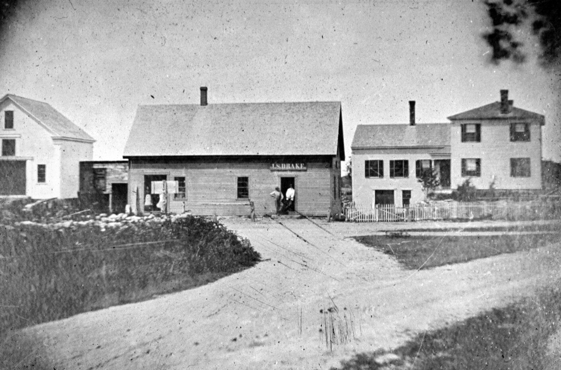
Frank Happy Saturday! I've just returned from an annual Easter Egg Hunt our church holds each year (we did miss a bit the last two) and it was so good to see young children excitedly gathering their eggs! The smiles on their faces made all the effort worthwhile. Next Sunday we will gather at Sheep Pasture for a community Easter Sunrise Service for the first time in two years. As spring approaches, it is wonderful to see a return to more normal times. Take a good look at the photo below and see if you can figure out where this location is. One clue is the name on the building in the middle. Another clue is what is missing today - everything in the picture! As we look at Easton then and now, today's photo shows some of the extraordinary change around town. Taken about 1880, our photo today looks at the Easton Five Corners before it became a major confluence of main roads Formed by the intersection of Bay Road with Foundry Street and Depot Street, the area was once home to stage coaches, foundry workers, farmers, and a tavern. In this image, we are looking north with Bay Road in the foreground and Foundry Street crossing from left to right, creating a small grassy area in the fork. Dominating the picture are three buildings related to the Drake family: the old Drake house at the right, the Joel S. Drake Store in the center, and the Drake barn on the left. Joel Drake, who probably built his home around 1820, also ran a store for many years. His son, Joel S. Drake ran the store after his father retired from the business. The store was a popular spot, especially with the former Keith Tavern nearby, and one can picture the neighbors gathering around the cracker barrel or wood stove to discuss affairs of the day. Bay Road continues across the corner and would angle off behind the Drake House. I was always told by the Drake and King families that the large ell on the rear of the house was a much older building, and may have been the Keith tavern. I have very vague memories of the old store building still standing, though it was no longer in use and in much disrepair. I do remember the house, and I especially remember a bad fire that destroyed it around 1964 or 1965. Growing up right down the street, I used to watch for dad's car as he came home from work. On the day of the fire, traffic was completely disrupted as the house burned, making him very late for his dinner that night. And so in a matter of moments, everything disappeared. Today, the Five Corners is one of Easton's busiest intersections and agateway to a rapidly growing area. Where Drake's Store once stood, a Sports Gas Station (Rico Petrocelli of the Boston Red Sox was a business partner) once operated, and that was eventually replaced by a modern Mobil Station. Just off to the right is a CVS Pharmacy, another gas station, a Burger King restaurant, and behind that is Shaw's Plaza which triggered the building boom in the area in 1984. To the left, and out of the photo is yet a third gas station that once belonged to Charlie Barbboza, a second drugstore that has since become a Dollar Tree, and another small stripmall with the popular Maguire's Restaurant and other businesses. Today multi-turn lanes and advanced traffic controls have replaced the quieter days of the dirt road and stagecoach. The photo that follows was taken from approximately the same spot as the original photo. How things change! Until next week, stay well,
Frank Happy April greetings! True to her nature, April arrived Friday morning with a torrential downpour, followed by teasing glimpses of sun. Perhaps April provided her own April Fool’s Day?
Please join me in congratulating OAHS Girls Basketball Coach Elaine (Laney) Clement-Holbrook and our 2021-22 OAHS Girls Basketball Team who won the Division 2 State Championship March 19 with a victory over previously unbeaten Norwood! The girls finished the season with a record of 22-3. Extra special congratulations to Laney as she heads into retirement after a 46-year career. She retires as a three-time State Champion (2006, 2010, and 2022), 44 years out of 46 with postseason appearances, 19 Hockomock League championships, and 4 sectional titles. She is also the winningest Girl’s Basketball coach in Massachusetts history with a career record of 733-244, 100 wins more than the previous record. Thank you Laney, and go Tigers! This week I will begin a series I call Easton Then and Now. I will use photos from our collections along with modern images taken from the same location that together remind us of how much has changed (or maybe in some cases, hardly changed at all.) What better place to start than dear old Bay Road? Originally a Native American migratory route between summer and winter encampments, the trail became a stagecoach road in the early Colonial years of Easton’s history. Taverns, farms, stonewalls, and milestones dotted the rural landscape as the road through Easton ran from Stoughton in the north to Norton in the south. Bay Road itself still follows its original path through Easton with very little deviation from its original footprint. Our photo today was taken in 1895 by an unknown photographer. It looks south from about the area of the current 469 Bay Road. The road looked this way a hundred years earlier or better! You can get a feel for how rural the area was during that time. The house on the left was the farm of the George Williams family. The house was built in 1884 on the site of a much older home that burned in 1882. Bay Road is a dirt road, and you can easily see the marks left by horse drawn wagons and carts. Stonewalls line both sides of the road, and the land is pretty well cleared by generations of farmers whose work also created those stone walls. On the right in the distance is the Josiah Keith House and barn. The house, built in 1717, is the oldest house standing in Easton. The barn, which predated the house by a year or two, burned August 4, 1902 after being struck by lightning. In this one photo you have a great look at the oldest house in Easton on the oldest road in Easton. The photo I took earlier this week from approximately the same spot as the old photo still imbues the rural feel of the area even with some development. There are more homes along the road, giving the old Williams house some neighbors. That house is visible between the trees at the left and keeps its traditional white color as it had in earlier days. The stonewalls are still evident though they have been broken up to allow for driveways. Pavement covers the road and signs warn of the curve ahead. Note that the Keith house is no longer visible in this photo as more than 125 years of growth have taken over the sides of the street and the old farmlands have slowly returned to their wooded heritage. Bay Road is a pretty busy place at times, and morning and afternoon commuters use it frequently since it connects a little further south with Route 495. Still, in a quiet few minutes, one can imagine the squeaking wheels of the stage and the neighing of horses as they draw near the Keith house, one of several taverns or inns on the road, for rest and refreshment. Have a great week, stay well, and enjoy spring, Frank |
Author
Anne Wooster Drury Archives
June 2024
Categories |
Easton Historical Society and Museum
PO Box 3
80 Mechanic Street
North Easton, MA 02356
Tel: 508-238-7774
[email protected]

