|
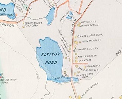
There used to be a Flyaway Pond in Easton. Now there is the Flyaway Pond Management Area. In March of 1968, Flyaway Pond flew away. There was a breach of the dam after heavy rains; the dam broke and tumbled a short distance to where it still sits today. The dam, built by the Ames Company in 1845, created the 50 acre pond, which harnessed needed water power for the growing Company. An 1895 map showing Flyaway Pond. Apparently the Ames Company monitored the dam over the years, especially during storms, but by 1968 the industry and the town had changed. The shovel works had begun to shut down by 1952. No one was watching as the rain continued to fall that March. As Ed Hands writes in Easton’s Neighborhoods, “Shortly after 5:30 pm, (3/18/1968) a large section of Flyaway Dam collapsed, unleashing an estimated 350,000 tons of water on North Easton. The burst of water uprooted trees, washed away cars, overturned two loaded freight cars and damaged houses.” I remember walking around the area of the dam within days of the flood, climbing over fallen trees that spanned what was left of the ‘pond’, now an otherworldly jumble of demolished trees, spewn concrete, and moving water. I remember writing an essay about it in my sixth grade class. Prior to that day, as children, my siblings, cousins, and I, led by my father, often walked on weekend mornings from our house on Sheridan Street, up Coughlin Road, then right off Western Ave., through the woods to the Plains and across Lincoln Street to Flyaway. Maybe we’d stop at Pout Rock, then walk on, making sure to walk across the dam before turning back, slightly unsettled by the shooting from the nearby Ames Rifle and Pistol Club. We often found shotgun shells on the ground. I remember them as red or green-colored. Last Sunday I walked a trail in the Flyaway Pond Management Area that begins at the Easton Town Pool and meanders about, exiting the woods at Deer Run, a residential Road off Bay Road. A blue jay and an iridescent green bug were my only company, except for three mountain bikers who raced past me. The trails are more popular with bikers than walkers, I think. The warm, slightly humid air was regularly punctuated by gunshots and occasional murmurings of flowing water. Well-constructed boardwalks spanned wet areas. It amazes me, wherever I go in town, including here, there are always stonewalls in the middle of the woods reminding me of our colonial past. The trail is not a loop so to walk it out and back is over four miles. Scenes along the way: Boardwalk. Parts of the trail are incredibly rocky, especially as one heads left from the dam area. Step carefully. In some places further on, the ground is riddled with tree roots, in others, fallen pine needles. The ubiquitous stonewall. Stone walls began to appear the closer to Bay Road I walked. Hikers or bikers can continue on, crossing Bay Road and taking Bob's Trail into Borderland State Park. Incredible green foliage. This was toward the end of my walk back to the old dam location.
It was a beautiful and nostalgic walk; I strongly suggest enjoying it if you live nearby. Also a nice hike, and more remote- you'll feel completely alone- is a fairly new trail (2021) behind the Edwin Keach Park off Chestnut Street. Quite a long walk and not a house or person in sight. Depends on your preference! “In every walk with nature, one receives far more than he seeks.” – John MuirAnne Wooster Drury [email protected]
1 Comment
6/18/2023 07:01:04 am
Great memories of walks with my dad in later years. A nice Father’s Day memory❤️.
Reply
Your comment will be posted after it is approved.
Leave a Reply. |
Author
Anne Wooster Drury Archives
June 2024
Categories |
Easton Historical Society and Museum
PO Box 3
80 Mechanic Street
North Easton, MA 02356
Tel: 508-238-7774
[email protected]

