|
Unionville
Even well-built businesses and roads are sometimes as fleeting as the first snowflakes and on reflection it seems like they disappear in no time at all. Unlike snow, sometimes they leave permanent traces behind. One day in early December, the first small snow fell in Easton, drifting somewhat lazily through the heavy cold air. Having received some interesting feedback from some members in response to my last newsletter (more about that in another newsletter), I am lingering in the Unionville area. The first settler in what we now call Unionville was William Phillips (circa 1720). Roads are key to the growth of neighborhoods. “Growth began after the development of a road to Stoughton. This road ran roughly parallel to but generally west of the present day Washington Street. It is mentioned in records as early as 1719 and was first surveyed as a road in 1728.” (Easton’s Neighborhoods, Ed Hands) Early Unionville depended on the Dorchester Brook. The brook travels south into Easton from Stoughton and runs under both Union Street and Elm Street extension. Early businesses included a sawmill on Union Street (1724-5 to 1829) close to the Brockton line and another further south off Elm Street extension where Eliphalet Leonard Jr. operated a forge and furnace for making steel. Both used the resource of Dorchester Brook. Traces of these businesses have disappeared. Today there are still traces of Monte’s Ice Company, a business that once operated on Elm St. extension. Fred Monte took over an existing icehouse in 1927 and ran it until 1967. But 1967 is not that long ago. And what's left is largely built of glacial rock that was already here, and will be here long after we're gone. 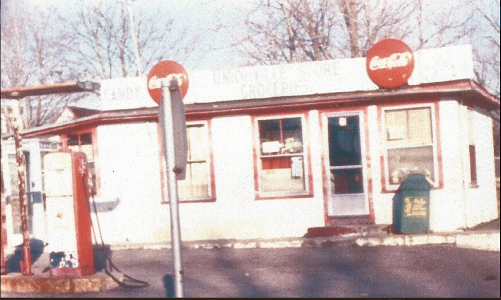 74 Washington Street, Unionville. This building, built in 1930 was on the corner of Washington & Union Street. Sometime during the 1940’s and 1950’s it was known as Peaselee’s having been bought by Floyd and Dorothy Peaselee and operated as a grocery store. Later it was sold to James and Lucinda Murphy. Neighborhood children walked there for candy; sat on the big rock to eat it. Today the store no longer exists. Below is what the corner looks like today. 74 Washington Street, Unionville. This building, built in 1930 was on the corner of Washington & Union Street. Sometime during the 1940’s and 1950’s it was known as Peaselee’s having been bought by Floyd and Dorothy Peaselee and operated as a grocery store. Later it was sold to James and Lucinda Murphy. Neighborhood children walked there for candy; sat on the big rock to eat it. Today the store no longer exists. Below is what the corner looks like today.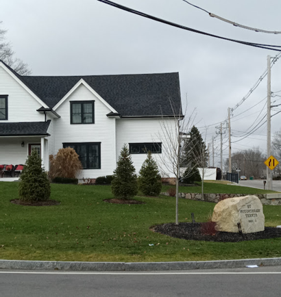 Site of Peaselee’s store as it looks today. Site of Peaselee’s store as it looks today. 181 Washington Street, Unionville. Swift’s Store, built in 1895. First known as Swift’s Grocery Store, later McMenamy’s Hamburger House, today the Beanery. 181 Washington Street, Unionville. Swift’s Store, built in 1895. First known as Swift’s Grocery Store, later McMenamy’s Hamburger House, today the Beanery. 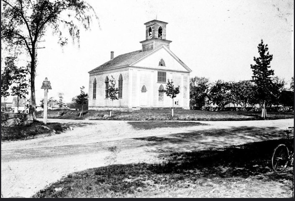 A bit further south on Washington street from Swift's Grocery, on the corner of Elm, was the Square Top Methodist Church. The land for the first church was purchased in 1795. To the left can be seen a corner of the Washington Street Cemetery. The first church here was subsequently moved and the Square Top was dedicated in 1830. It was torn down in the early 1900's. Many different businesses have been located here since. Today the land is part of a private residence. A bit further south on Washington street from Swift's Grocery, on the corner of Elm, was the Square Top Methodist Church. The land for the first church was purchased in 1795. To the left can be seen a corner of the Washington Street Cemetery. The first church here was subsequently moved and the Square Top was dedicated in 1830. It was torn down in the early 1900's. Many different businesses have been located here since. Today the land is part of a private residence.Some remains of Monte's can be seen in the woods off Elm St. extension, the church and Peaslee's are gone now, Swift's store has undergone its own metamorphosis. Time passes. I make my way out of the woods near Monte's old Ice House, getting caught up by briars as I do so. I've been poking around the site but the undergrowth and damp ground make it difficult. I emerge from the woods to see my car parked precariously on the edge of the road. And in the blink of an eye, it's stopped snowing. Anne Wooster Drury ehsnewsletter12@gmail.com
0 Comments
 Please stop in at the Easton Historical Society and Museum for our December Open House. It will be from 12-4 on December 17th. Great last minute gifts, including glass ornaments, puzzles, vintage Easton maps, books, coloring books for the kids, and so much more. See our new display and view our Station’s “bull’s eye” window from the inside! Also, our Ames tool belt buckle collection and famous suffrage movement artwork from Blanche Ames Ames will be on display. As always, refreshments will be served.
SPECIAL NEWSLETTER/GUEST WRITER Today’s newsletter is written by Chris (Mark) Bergeron after a recent gathering to honor Private First Class Edward “Smitty” Smith, graduate of Oliver Ames High School, the first Easton resident to die in the Vietnam War. “Edward ‘Smitty’ Smith was remembered on Saturday November 4 in a poignant gathering at Beaver Brook Wood of family members, friends, veterans, and a teacher who’d known him since 1962 as an outstanding athlete who lived his life with fearless exuberance and the first Easton resident to die in the Vietnam War. Surrounding a boulder inscribed with Smith’s name and located at a trailhead leading into serene town-owned woods off Poquanticut Avenue, about 25 guests, including five of Smith’s siblings, their spouses and children, shared their memories of their daredevil brother with others and then heard from three Marines who had accompanied him on his last patrol and written his parents heartfelt letters after his death. The hour-long gathering was organized by Mark Bergeron and Dale Kerester, an Easton community activist and Lion’s Club member, who provided customized frames for photographs of Smith in high school and Vietnam to be hung from a nearby tree. At the gathering and at a later meal at Leandros Italian Restaurant, Kerester played pre-recorded telephone calls from Marines David Backer and Jim Rowe II who remembered Smith as a dedicated and courageous platoon member whether in a firefight or teaching survival skills to newcomers. Setting an elegiac tone, brother Jim Smith read a free verse poem, “A Requiem for Smitty,” written by ‘a friend’ to be hung from a nearby tree with his photos that imagined Smith speaking from the dead and asking a passerby to look into his face: ‘I hope they can understand how short and precious life is …/Look into my face – and all the other faces like mine – and remember us.’ In letters to his parents, the Marines who accompanied Smith on his final mission recalled him as courageous under fire, helpful to new platoon members and thoughtful about the complexities of a divisive war. By the rock Kerester played a recording of former Marine David Backer, of Oregon, reading a letter he wrote Smith’s mother describing the time her son saved him from stepping on a Viet Cong booby trap, gave him leather boots to protect him from the soggy jungle and taught him to work with him as a ‘tail-end Charlie’ who ensured no enemy fighters were sneaking up from behind other Marines to ambush them from behind. ‘As I write this, I’m looking at some leather bootstraps that Smitty braided for me to give me good luck. It has constantly reminded me of Smitty and how kind he was to me. My heart aches that he didn’t get to live a longer life and continue his kindness,’ he wrote. Later at Leandros Restaurant, Kerester played an 18-minute recording of former radio operator James Rowe II, of Pennsylvania, recalling an early discussion with Smith while they protected a Montengard village that he’d left college to join the Marines so he could draw his own conclusions about the justness of the war. Guests listened raptly as Rowe described how the 11 Marines dug in atop a small hill behind enemy lines on a reconnaissance mission. Just after night fell, he recalled Smith firing an M-60 machine gun and shouting ‘Here they come’ as the Viet Cong attacked the outnumbered platoon. After the firing stopped, Rowe recalled radioing, ‘We have one American kilo India alpha,’ stunned to realize he was reporting Smith’s death in phonetic radio code. Two Easton residents who’d known Smith since high school in the mid-1960’s remembered him in their own ways for transcending the usual social conventions of being an outstanding athlete and reaching conclusions about classmates on his own. Hazel Varella, who taught 41 years in Easton’s school system and presently serves as treasurer of the Easton Historical Society, said Smith always enlivened her classes with his provocative opinions and, despite a seemingly outspoken public persona, took what he considered the ethical path. In a letter written and distributed to Smith family members for this event, Kevin Dee, a high school classmate who joined the Marines the same time as Smith, concluded the letter as if speaking to him; ‘I think of you often and what you all gave up. You didn’t deserve to have that taken from you. We can honor you by remembering your sacrifice and, as one of the lucky ones, by keeping our promises and not wasting our lives.’ In a voice strained with emotion Bergeron read a short letter to Smith’s parents from former Marine Suluki Qawiy, now member of the Nation of Islam who was born Roger Smith, in which he described Smith as ‘one of the roughest human beings I have ever come in contact with and a rebel. A rebel means he believed in fair play and tried to change what he felt was wrong in the world. To me, freedom, justice and equality was his method of life and that was one of the reasons I loved him so much. … When Smith had his eye on a goal, he went for it all the way. Please let us not refer to those who passed away as dead. They are alive in our hearts. Your brother, Suluki.’” Thank you to Mark Bergeron for providing this moving tribute to his childhood friend. Anne Wooster Drury ehsnewsletter12@gmail.com Upcoming: Today, Saturday December 2nd – EASTON GARDEN CLUB HOLIDAY GREENS SALE will be held from 9 to 12 at the Historical Society. Purchase some beautiful greens for your holidays! In addition, the RR Station is now decorated with festive white lights and the ‘official’ lighting will take place on the same day. The RR Station will remain open until 6 pm. Old Road On Sunday November 19th Director Steve Anderson and I met up with members of the Stoughton Historical Society, led by Dwight MacKerron, off Roche Bros Way to access the railroad tracks. This section of track runs from the North Easton Station, behind Roche Bros Supermarket and on to Stoughton center to the Station there. We were looking for remains of an old road that connected Easton and Stoughton prior to the laying of the turnpike now known as Washington Street. It was a sunny and brisk day, but not too cold. It was a short walk to the tracks and once there we walked north toward Stoughton. 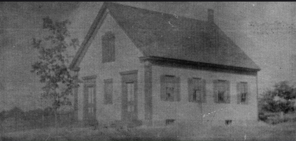 One stone wall, one side of the old road. Before long a very large glacial rock could be seen off to the east. Once beyond the rock Dwight pointed out the remnants of the old road. It runs for perhaps seventy-five yards and is bordered on both sides by stone walls. The road was originally discovered by Dwight MacKerron and members of the Stoughton Historical Society. According to him the road was shown on at least one old map. He believes the road- (the part we saw was in Stoughton)- probably swung east toward Washington Street. In the other direction it ran toward Easton. Exactly where is currently unknown.  Glacial rock. On our walk we came upon a small animal skull laying on top of the ground- a bit of a surprise, a railroad spike, and telegraph/telephone poles (pictured below) from sometime after the railroad line went in. The Easton Branch Railroad opened from Stoughton to North Easton on May 16, 1855.  Fallen pole.
Another Old Road Chaffin in his History of Easton (Highways) writes that some of the early Easton roads were merely cart-paths and that “there are a number of abandoned roads in Easton that were once considerably used highways. There was one from North Easton village to Solomon Foster’s place, and so round east to the old Stoughton road, now Washington Street.” Solomon Foster lived close by the Stoughton line. In Chaffin’s time this road was “not yet obliterated.” Solomon R. Foster fought in the Civil War and is buried in the Washington Street cemetery. In another passage (Old Abandoned Homesteads) Chaffin writes, “Not long after the incorporation of the town a few settlements were made up in the extreme northeast quarter, and an old road ran…. northerly from the village of North Easton nearly to the Stoughton line, and thence easterly, and so round by Washington Street.” In the village there was a road sometimes referred to as the Sol. Foster Road, that according to Chaffin did not fare well in the long run. The road was voted in 1744 and later in 1772, though little was done to maintain it. In Chaffin’s time “it was no longer a thorough-fare to Stoughton and was in fact very early superseded by the other two roads to that town.” Where Solomon Foster’s road was exactly is also unclear. Thank you to Dwight MacKerron and the Stoughton Historical Society for a nice walk and great information. In granite cold, I Follow rust-colored Fragments of old tracks Going nowhere Anne Wooster Drury ehsnewsletter12@gmail.com On Sunday November 12, visitors to the EHS&M heard from six speakers. Ken and Diane Sterling, members of the SAR and the DAR, respectively, spoke of their own long family histories in this country from the time of the Revolutionary War. David Ames Jr. spoke about his relative Second Lt Oliver Ames, Jr. who was killed in combat in France in WWI and his own father David Ames, Sr, who proudly served in WWII, decoding the tapes that detailed losses at Pearl Harbor and accompanying the ranking admiral on duty in delivering the news to the White House. Easton resident John Amorim shared his experience in Vietnam after he enlisted in 1963, the constant need to be on the lookout for booby traps, and his sadness on hearing of the death of fellow Easton resident and OA grad Pfc Edward Smith. Frederick Allen Coe Jr.’s military duties included combat force protection and electronic security systems operations in both Afghanistan and Iraq. Since September 11, 2001 he has been deployed on three military operations, including OPERATION ENDURING FREEDOM and OPERATION IRAQI FREEDOM. 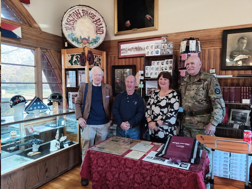 Left to right: First Vice President David Ames Jr., John Amorim, Elizabeth Riley, Frederick Coe, Jr.
Elizabeth M. Riley, Lieutenant Colonel (Ret), served in the US Army from 1984 to 2013; her specialty was logistics, plans, operations and training. Her career included assignments in the Army National Guard, Army Reserves, and active duty. Listeners were impressed with the selfless service given by these individuals and the gift of those who solemnly pass their story on. At this time we especially remember those who did not return. I find myself sympathizing with the words of Emily Dickinson, It feels a shame to be Alive-- When Men so brave—are dead-- Anne Wooster Drury ehsnewsletter12@gmail.com UPCOMING EVENT: Please join us! I found it! The Dailey Homestead on Stonehill College property. I mentioned Dailey in an earlier newsletter about Stonehill; Dailey was an early settler in Easton. “John Dailey (Daley/Dayly) ‘pitched’12 acres (1708-9) on Stone-House Plain.” He was here before 1708 and originally a native of the north of Ireland. (Chaffin) He was a hogreeve, or hog constable. After reading, or re-reading, about the find, and subsequent research and excavation beginning in 1996, I wanted to see the site for myself. Of course, I did it the hard way- I did not go directly to the College archives. I had tips from three different people, and off and on, over the past several months, I have wandered the vicinity looking for the site. It was not easy to find. There is a path, though a rather faint one off a more well-traveled path, and the site is marked- once you manage to find it. Artifacts are stored in the Stonehill College Archives.  Sign posted near Dailey homesite on Stonehill College property. Found at the site were a bronze coin with a likeness of George II, a musket ball, pieces of window glass, china imported from England and China, and part of a tobacco pipe. Artifacts are stored in the Stonehill College Archives. Remains of a well at Dailey site near house foundation. Photo of Dailey house foundation.
The woods were quiet and calm the day I found the site, the sun shining through the leaves of the surrounding trees, the occasional brown leaf silently drifting down to the ground. It was a good moment to reflect on the past and try to imagine what life was like for John Dailey and his family. It was worth the hours spent searching. The photos are mine, but some information is from the Stonehill Alumni Magazine, Fall 1999. Anne Wooster Drury ehsnewsletter12@gmail.com A reminder that today, Sunday, October 22, the monthly Open House at the Easton Historical Society takes us back to the decades when many of us reading this newsletter grew up- the 1950’s, the 1960’s, and the 1970’s. Each of these decades provided very different experiences for those who came of age at the time. Perhaps the fifties were more innocent, I don't know (?), while the sixties were politically and culturally turbulent, and it was in the seventies that the Beatles disbanded and disco was born. As we’ve grown older, perhaps we’ve become more aware of, and grateful for, our hometown and the spaces we played and studied in. As we grew into our later teenage years and beyond, some of us stayed, some of us left for good, and some of us left, but later returned to raise our own families. The following is a remembrance by my sister Rosemary (Wooster) Duphily on those ‘in between’ years when we were "finding our way in the world". In her remembrance she focuses on the local 'music scene' in the 1970's. Local Entertainment in the 1970s Coming of age in the 1970s had its benefits and challenges. In the mid-to-late 70s, most of us were continuing our education at college or working our first full-time job, with the added responsibilities of managing studies, adjusting to work schedules, and living at home, on our own, or in dorm rooms during the week. But when the weekend rolled around, we wanted to have some fun! I can remember traveling to Club California in Quincy, Shenanigans in Canton, and a variety of fairly local clubs featuring music, dancing, and drinking (the drinking age was 18)! During this time, right here in Easton, was the well known Olde Forge Tavern on Rte. 138. During my college years, I enjoyed the entertainment at the Olde Forge with my friends listening to “Red Eye”, “J.D., Billy & Ken”, "Midnight Traveller”, and the “Beaver Brown Band”. I looked forward to Friday and Saturday nights when we would drink pitchers of beer, socialize, make new friends, and dance to our favorite songs. I even worked as a cocktail waitress at the Olde Forge, experiencing the best of both worlds - making money while serving drinks to friends and listening to great music. The Olde Forge Tavern provided us with a local and comfortable entertainment venue, while we were still finding our way in the world. The John Cafferty & the Beaver Brown Band were from Rhode Island and began their career in 1972. They played in Easton at The Forge in the 1970's. Image 1980's. If you are local, we hope to see you tomorrow at the train station, 12:30-4:30. Anne Wooster Drury ehsnewsletter12@gmail.com It’s that time of year again when spooky things are seen around town. And they’re all looking forward to the Open House on Sunday October 22nd when we will revisit Easton in the 1950’s, 60’s, and 70’s! Below is a scene from the Town Pool, 1962. Do you remember riding your bike there on a hot summer day? Taking swimming lessons early in the morning when it was still too cold? Jumping off the dock? Taking the test for the ‘green’ tag? Then you’ll want to stop by the Railroad Station to see our exhibits. Town Pool 1962. Easton Patriot newspaper. Did your family ever pick up pizza from the Crossroads Café? Maybe on a Friday or Saturday night? A special treat. Photos, Easton Patriot, 1962.
Did you go to Oliver Ames High School? Football games at Frothingham Park? You could hear the cheering and the band playing blocks away. Remember Val “Muzy” Muscato? (On the left in the above photo.) Or basketball or baseball games? Maybe you played a sport for OA. Not until 1973 was the first Girls’ Track Club formed. The club officially became a team in 1974. Things were different then. If you remember sock hops, poodle skirts, mini-skirts, drive- in theaters, Walks for Hunger, James Taylor, candy cigarettes or wax lips, please join us! Twelve-thirty to four-thirty. Now the first of December was covered with snow and so was the turnpike from Stockbridge to Boston Though the Berkshires seemed dreamlike on account of that frosting with ten miles behind me and ten thousand more to go There's a song that they sing when they take to the highway a song that they sing when they take to the sea a song that they sing of their home in the sky, maybe you can believe it if it helps you to sleep but singing works just fine for me So, goodnight you moon light ladies, rock-a-bye sweet baby James Deep greens and blues are the colors I choose, won't you let me go down in my dreams? And rock-a-bye sweet baby James Anne Wooster Drury ehsnewsletter12@gmail.com A reminder- Sunday October 22 there will be an Open House celebrating the '50's, '60's and '70's. If you have any artifacts from those decades we could display, please contact the museum, or me, at the email below. Thank you! Hope to see you there. Also, a correction on the last biweekly. Wheaton Farm is larger in area than the part of Borderland that lies within Easton! A Peek Back in Time, Easton Town Reports 1870-1 & 1873-4 On a dreary, rainy, Monday I took a look back in time by browsing through some old Easton Town Reports. I was drawn to Death Records and Almshouse Records. What I found made me grateful for the basic, and not so basic, medical advances and social services that we enjoy today. Causes of death were quite different in the late nineteenth century and an inordinate number of people died young. Many of us have had the experience of walking through an old cemetery and seeing this painful truth carved in granite. Among the older people, some causes of death sound familiar, not so much, others. Familiar causes of death were: pneumonia, heart disease, kidney disease. Less 'modern' causes were typhoid fever, consumption, and cholera morbus. Photo from a page of the 1870 Town Report, Deaths. In 1870 Easton resident Caleb Swan died at the age of 75. The record says “erysipelas”. Erysipelas is a skin infection caused by streptococcus bacteria. It is also called St. Anthony’s Fire and today is usually treated with antibiotics. Also in 1870, Sarah T. McDavitt, 2 months and 4 days old, died of inanition. Inanition is defined as “exhaustion due to lack of nourishment”. She was one of two that year. A fifteen-year-old boy died from cephalitis, an obsolete term for encephalitis. Hydrothorax, paralysis brain, and Par. Insanity (1873) were other diagnoses. A 1-year-old died from a burn. Of 41 deaths, 9 were due to 'Old Age', for 3 very young children, no cause at all was given. People, especially young people, died from dysentery and cholera, diseases that today primarily affect countries in the developing world.* *A 6 month old, 7 month old, and a 48 year old in 1870. In the year ending in 1874 there were 79 deaths; 43 of those deaths were of people under the age of forty. More than half. In contrast, in 2000, there were 163 deaths in Easton, none were under the age of 20. Between the ages of 20 and 40 there were several deaths; the causes were not listed. In 1873 young people under age 10 died of- dropsy of bowels (1), congestion of lungs (1), cholera (7) smallpox (2), inflammation of bowels (1), convulsions (1), disease of the brain (1), inanition (3), croup (1), teething (1), meningitis (3), scarlet fever (1). The Almshouse The purpose of the Almshouse was to take care of the poor. The town bought land and a farm in 1838 to use as a poor farm and an almshouse. It was located in the general vicinity of the Center School. A new, improved almshouse was built in 1874. According to Ed Hands in his book Easton's Neighborhoods, prior to 1838 the poor were cruelly auctioned off to the lowest bidder. Often they were old or mentally disabled. A ticket to admit the bearer for one night only, 1871. Appearing in the Town Report from Almshouse in 1893: Expenses outweighed income as an unusually large number of tramps, 289, were lodged and fed that year. The number of paupers was 1/5 higher than previous year. Outside of the Almshouse itself, aid was given to 57 additional people for a total of $2,157.79. A portion of the Almshouse report in the Town Report 1873. There were equal numbers of men and women. Two 'inmates' died that year.
Although our current institutions created to manage the sick and poor are far from perfect, they are an improvement.over past practices. The forecast for tomorrow is 74 degrees and sunny. Anne Wooster Drury ehsnewsletter12@gmail.com A few announcements: The station will be closed Wednesday, September 13 and Friday, September 15. Also, don't forget the Open House scheduled for Sunday, September 17- the dedication of the Lee Williams Family Colonial Shed and a cookout for our members and donors- in appreciation. Twelve-thirty to four- thirty. New memberships will be available at the door. Also, the Society is planning an Open House for Sunday, October 22, that will focus on "Growing Up in Easton in the '50's, '60's and '70's". We are looking for 'artifacts' from those decades. If you have items we can display please notify the Society at eastonmahsmuseum@gmail.com or email me at ehsnewsletter@gmail.com. Thank you in advance! To everything – turn, turn, turn There is a season – turn, turn, turn These lyrics, written in 1959 by Pete Seeger, came to mind as I finished my recent walk at Wheaton Farm. As soon as late August, early September, the natural world is already, in quiet, barely discernible ways, signaling a turn of season. Whether it’s the color of berries, the turn of a leaf, or an abundance of mushrooms, little hints are everywhere 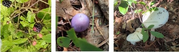 Most of the land that makes up Wheaton Farm Management Area was once agricultural land. It is named for Daniel Wheaton (1767-1841) whose house still stands at 519 Bay Road and was the first major purchase of Easton’s Conservation Commission. Many Easton citizens worked very hard to save Wheaton Farm from development and in May of 1967 the first acquisition of land was officially dedicated. During the mid-sixties Conservation Commission members fought to procure Wheaton Farm and to preserve it as a green space. Serving on the commission (1965, 1966, 1967) were Alice B. McCarthy, Raymond Taylor, John Freitas, Elizabeth Ames, Charles Willis, and Clifford Grant. Other individuals instrumental in acquiring Wheaton Farm include Evelyn C. White, Virginia Reusch, and John E. Grant. Today, the land area comprising the Wheaton Farm Management Area is greater than Borderland State Park. At the start of the trails off Bay Road is a pollinator garden. Shortly after I began walking, this butterfly (below) greeted me and hung around long enough for me to take its picture. Trash bags are conveniently located a bit further along for dog walkers. There are several different trails of varying length. My butterfly friend. Also located at Wheaton Farm, since 2019, is the Ed Hands Community Garden, which makes garden plots available to community members. The plots here are crammed full of produce and flowers at the end of August. In this especially rainy summer, many vegetables are ripening late. On other parts of the property Langwater Farms has grown produce since 2014. Hikers and walkers (many with dogs) enjoy the property; the Bay Circuit Trail passes through, and hunting is allowed in season. Daniel Wheaton’s old farm serves new purposes. I’m sure the current residents of Easton appreciate their fellow citizens’ foresight and their commitment to land conservation that began decades ago. 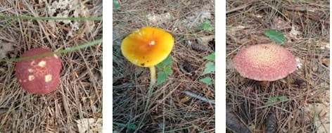 More mushrooms. 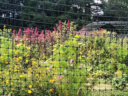 Ed Hands Community Garden.
Tomatoes rot in the compost pile Nearby, a rusted watering can, Broken chair and a red wheelbarrow Reminisce about the harvest Anne Wooster Drury ehsnewsletter12@gmail.com Easton has a little known, but highly respected, author in its past. He once resided at 261 Purchase Street at a farm known as Glen Easton and later as Maplewood Farm. In 2016 Barnes & Noble issued a special reprint of James Rankin’s “Artificial and Natural Duck Culture”. The original was printed in 1906 and sold for 50 cents. Reprint of James Rankin’s book, 2016. “……this classic text introduces us to the basics of raising ducks, be it for pleasure, exhibition, egg production or meat purposes. Included are details on the major duck breeds, as well as how to raise and breed them for eggs or meat. Included are sections on housing, feeding, incubation of duck eggs, brooding and care of ducklings and more. Of particular focus is the management of ducks specifically for meat purposes, including how to dress them.” Barnes & Noble 2016 Original book, 1906, 50 cents. James Rankin was born in Glasgow Scotland in 1830 and died in Easton in 1914. He was known as ‘The Father of the Pekin Duck Industry in America’ and his expertise was well-recognized. After buying the run-down Deacon Reed farm in 1874, Rankin began improving the property. In a letter to Chaffin, Rankin said that he “had bought the place for its possibilities.” By about 1876 he was well-known as an inventor and manufacturer of an innovative incubator for duck eggs, which he eventually patented. Every day a wagonload of Rankin’s ducks would be shipped via the Easton Center railroad to locations all over the United States. Rankin’s Monarch incubator worked equally well on chickens, geese, and turkeys; his hatch rate was never less than 90%. By 1891 he was hatching 4,000 to 5,000 chicks, which he sold as broilers and by 1906 he was raising 25,000 to 30,000 ducks per year. Original house, Maplewood Farm, now Easton Country Club, old pic. In 1908 Rankin sold his farm to Ezra Pratt. In 1914 Frederick Lothrop Ames II bought the farm and housed his prize-winning Clydesdales there. In 1923 Frederick’s widow sold the farm to Producer’s Dairy of Brockton. In 1945/1951(?) the farm was sold to Samuel Joseph and Mary C. Lombardi of Rhode Island. Initially managed as a dairy farm, in 1961 they began construction of a nine-hole golf course, today known as the Easton Country Club. Today Easton Country Club is a beautifully maintained eighteen-hole golf course. Today, Rankin’s advice is still sought out by members of the poultry community. The book’s content is available as an eBook at no cost through Project Gutenberg, www.gutenberg.org. 261 Purchase Street. Rankin house. Built in 1880.
Anne Wooster Drury ehsnewsletter12@gmail.com Sources: Easton Historical Commission Easton Historical Society History of Easton, Chaffin, 1886 Easton Country Club website |
Easton Historical Society and Museum
PO Box 3
80 Mechanic Street
North Easton, MA 02356
Tel: 508-238-7774
eastonmahsmuseum@gmail.com